Digitising An Exhibition

Since bumping into it during my little One Mile Matt project, I’ve been fascinated by the Bristol International Exhibition of 1914. This was a grand but short-lived 1 exhibition that took over a vast area of Bristol very near me, just south of the river in the Ashton/Rownham area, partly where the modern-day White City Allotments are sited. (Those allotments are named after the Exhibition, with its array of white gypsum plasterboard buildings.)
If you want to know more, Clive Burlton’s book Bristol’s Lost City (available from Bristol Books) is a fantastic source of information and pictures of the Exhibition. You’ll also find plenty more resources in the Bristol Archives, like this photo showing the grand scale of the exhibition, and also plenty of pictures at the ever-reliable Know Your Place Bristol (that postcard shows the huge replica of Bristol Castle, the Dominions Pavilions and the bandstand.)
Speaking of maps and the archives, one thing I took a look at during a session at the Bristol Archives’ searchroom back in February was item 37165/7/3, a plan of the site of the Exhibition which, according to Clive Burlton’s book, was “handed to journalists during their visit on 16th April 1914”.
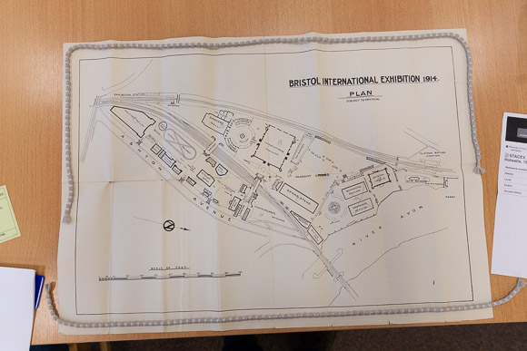
I took a snap of the plan and examined it at my leisure, but had problems relating it to the modern landscape — how big was it? Where exactly was the early roller coaster? How big was “Shakespeare’s England”, later taken over by the Bristol Battalion of the “Glosters” as some handy pre-built wartime accommodation? — and so a little mini-project was born.
First I took my photo of the plan and, over the course of many hours, manually digitised it into a vector format, admiring along the way the jaunty handwriting and attention to detail of the original draughtsman. (Sadly I didn’t have the time to reproduce aforementioned handwriting except for the big banner headline — the rest just had to be a reasonably close match from a stock typeface.)
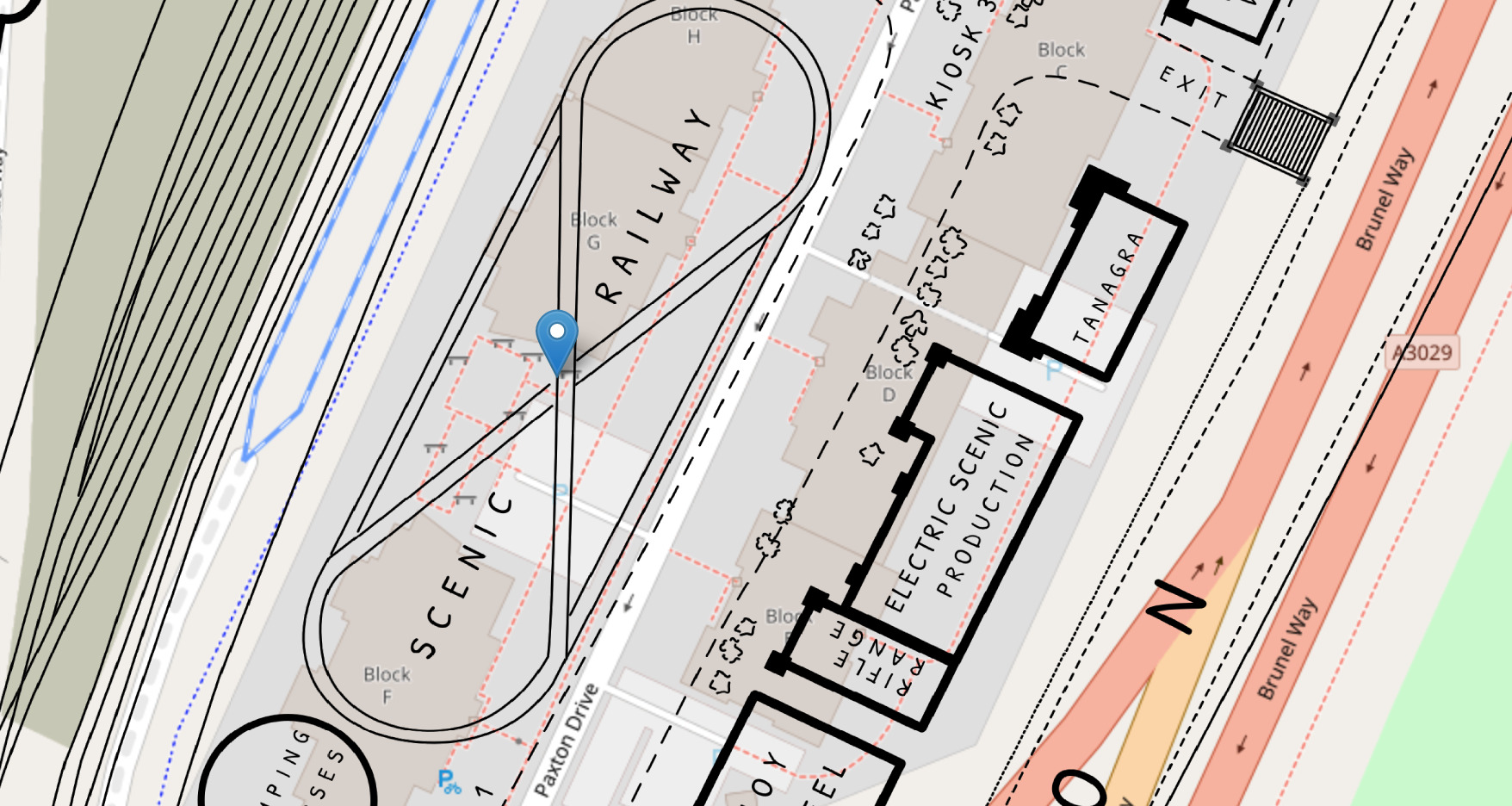
Then I rotated the whole thing to so that north pointed upwards, moved the title, compass and scale around to fit better, and located the whole plan as best I could on a modern map. I also rotated a few of the labels after this step to make sure nothing was too topsy-turvy.
The result corresponded startlingly well to the modern map. The draughtsman must have been working with a good surveyor and/or source map back in 1914. Several key points on the map that still exist — the platform bridge at the now-defunct Clifton Bridge Station, the Ashton Avenue Bridge, the junction of Ashton Road where the Bristol Tramways terminus used to be — lined up extremely well with no warping or strange transformations of the map necessary.
Once I’d done that, I dusted off some of the knowledge of putting maps on the web that I’d gained during the One Mile Matt project and ended up with http://exhibition.gothick.org.uk, a simple little website that lets you see the 1914 Exhibition plan overlaid on a modern map (thanks, OpenStreetMap, Leaflet et al.) You can zoom and scroll around, change the mixture of the old and new, and generally investigate what was where from a modern point of view.
The Bristol Archives were kind enough to waive the licence fee for reproducing the plan once they’d seen what I’d done with it (thanks, folks!)
I hope that the site is useful to anyone who, like me, couldn’t quite believe that there was once an enormous site that dominated the Bristol skyline for a short time, encompassing everything from from an art gallery to a shooting range, from Bristol Castle to the “House of Nonsense” and a host of other attractions, and is curious about exactly where everything was.
(I’ve also popped a few pins on the map that pop up some of the WH Smith postcards of the Exhibition, since I’ve been collecting them occasionally when I see them pop up on eBay…)
- tip: try not to create a giant exhibition in the middle of a city in the run-up to a world war without getting the city authorities on your side to begin with…[↩]